
(Blog Written by Donald Sutherland)
June 23-30, 2012 Thoughts:
The final week of June appears likely to witness the warmest readings relative to normal in parts of the East. In fact, compensating for the shorter wavelengths, much of North America looks to be warmer than normal. Moreover, with some hot analogs showing up, it appears increasingly likely that the first week of July could experience warmer than normal temperatures, too. Among the hot analogs appearing are 1966, 1969, 1977, and 1980. In fact, the latest run of the CFSv2 has much of North America and Eurasia warmer to much warmer than normal for July. Right now, it’s too soon to make a definitive call for July, but some hot analogs have persistently been in the mix.
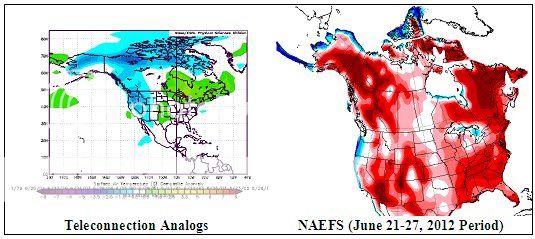
The charts below are as follows:
Left: The composite temperature anomalies for ENSO Region 3.4 anomalies of -0.2°C to +0.6°C, a PNA of -1.00 to 0.00, and an AO of 0.00 to +1.00 for North America.
Right: NAEFS (June 21-27, 2012 forecast)
All said, my thoughts are as follows:
– West Coast of the U.S. into British Columbia eastward into Alberta: cooler than normal.
– Southwestern U.S. much warmer than normal
– Remainder of North America warmer than normal with perhaps the Southeast being close to normal due to wetness and an area running from the Great Lakes to the Northeastern U.S. and across Quebec and portions of Atlantic Canada having the potential to be much warmer than normal.