
(Blog Written by Donald Sutherland)
July 1-7, 2012 Thoughts:
With the exception of the Great Lakes region, most of North America will likely be warmer than normal during the first week in July. Extreme heat is not likely in the eastern third of the U.S.
The charts below are as follows:
Left: The composite temperature anomalies for ENSO Region 3.4 anomalies of 0.00°C to +0.75°C, a PNA of -0.50 to +0.50, and an AO of +0.00 to +1.00 for North America.
Right: Observed decadal temperature trend for July
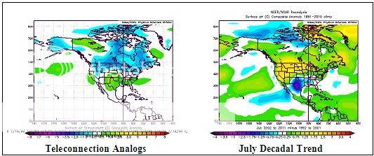
Although the teleconnection analogs suggest a large area of cool anomalies, even taking into consideration shorter wave lengths, the preponderance of guidance, along with the observed decadal temperature trends argue for a smaller area of cool anomalies.
– The NAEFS is warm almost coast-to-coast with a small are in the Great Lakes region being cool.
– Both the GFS ensembles and ECMWF ensembles favor widespread warmth in North America.
– The CFSv2 features near normal conditions in the Great Lakes area to New England and cool anomalies in the Pacific Northwest; the remainder of North America is warmer than normal
– The observed decadal temperature trends favor warmth in much of the area showing up as cool on the teleconnection analogs.
Taking all the guidance into consideration, my thoughts are as follows:
– Great Lakes region: Near normal with perhaps a small area of cool anomalies.
– Pacific Northwest: Near normal to perhaps a little cooler than normal
– Remainder of North America: Warmer than normal. The Central Plains into the Southeast could see the largest warm anomalies.
Finally, odds are increasingly tilting toward a warmer than normal July over much of North America. I expect to finalize the monthly analogs over the next day or two. However, some warm analogs including 1953, 1966, 1969 (the top June analog), 2001, and 2006 are very much in the mix. At the same time, 2009 is fading somewhat.