
Good Morning Everyone,
First, I want to wish everyone Happy Holidays !!!
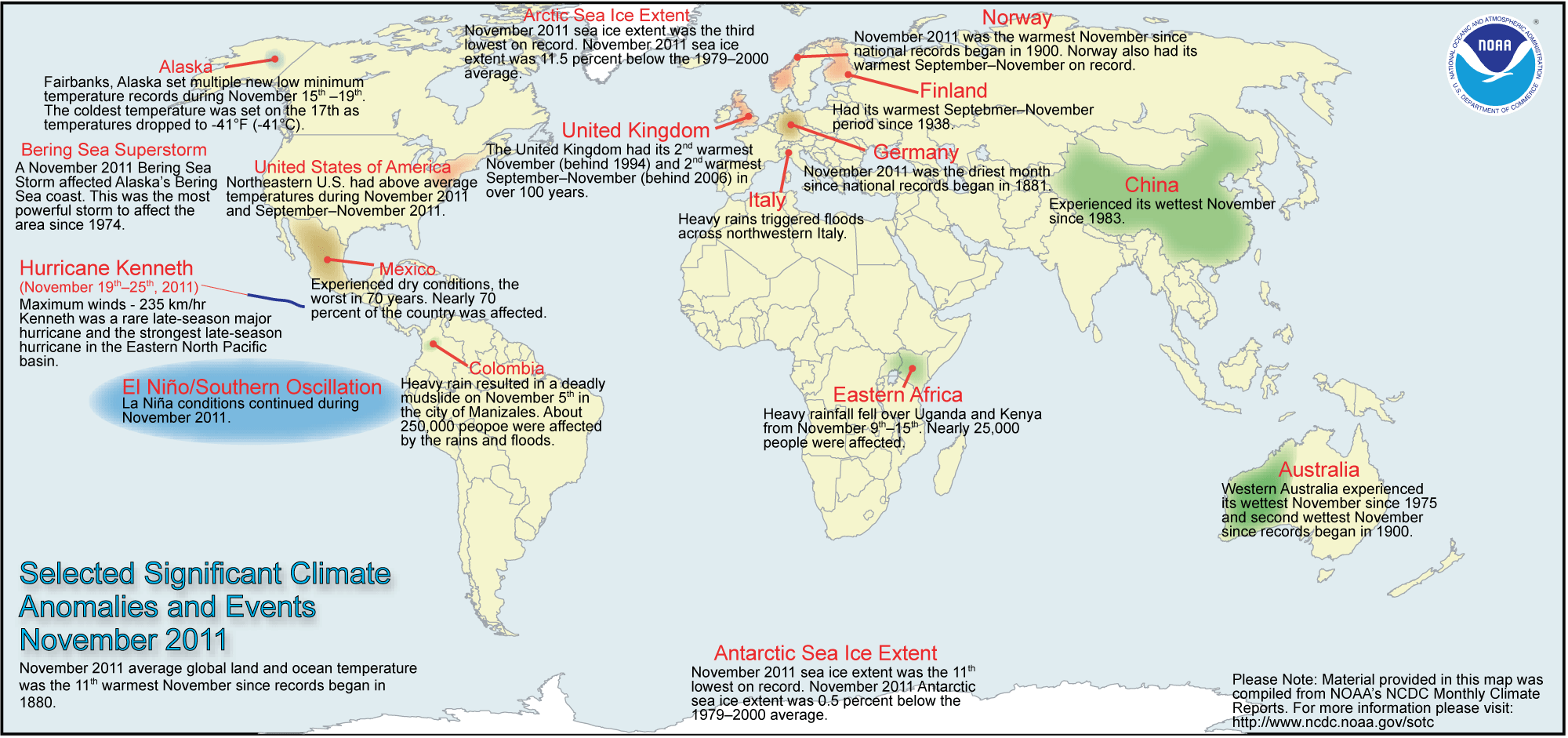
This morning, I wanted to get this climate review for November put together. I’m going to share with you a quick view of past weather events from November. One of the really nice websites out there is the National Climate Data Center. Let’s take a look how November went…
The first image shows what happen globally with regard to weather hazards. If you click on the image below, you will able to see it much larger.
Next, let’s take a look at the Significant Events for the month of November. If you click on the image below, you will able to view the full report for this month. Again, there is a lot of data they review for this month.

One of the more interesting images I always like to take a look at is the 500mb Height and Anomaly map. When you look at the 500mb map, you can get a sense where ridges and trough setup. In a way, its like looking at the big picture. The shades of red indicate ridging, while the shades of blue indicate troughing.
Let’s compare November of this year to last year. Click on the image to see November of 2010.

Next, let’s do something really cool and you can do this as well. Take a look from last year as we went from November to December. Notice how the upper air was setting up, especially for colder and snowier pattern for Middle Atlantic and Northeast. Click on the image to see December of last year. Notice as you go from November to December, check out the impressive the ridging, which is the red plotted over over Alaska, Eastern Canada and Greenland. Notice how much blocking was setting up over these locations. This would eventually lead to some significant cold over the Central and Eastern US as we went into December. I remember when I vacationed in Orlando, Florida that it was so cold, frost formed on the windows. Then we had the Boxing Day blizzard back on the 26th. I remember how the models were all over the place on that one. But the pattern was more favorable to get winter storms. This year, especially, when you this past November upper air map, we have more troughing plotted over the same locations I mentioned. We have a totally different pattern, which favors a more colder and wintry pattern for Western sections of the US, while over here in the East, a bit milder and wet pattern. Another point to mention about eastern sections of the US… Last year, the telleconneections were very favorable for a colder and snowier pattern. The Arctic Oscillation (AO) and the North Atlantic Oscillation (NAO) were both negative. Just take a look at December of last year. The December map speaks volumes when AO and NAO are negative. Obviously there are many more variables, but both these telleconnections play a huge roles during the winter season.. The NAO and AO are a key ingredient to getting favorable conditions for colder than average temperatures and winter storms. Right now, both are positive and as you can tell, the pattern just doesn’t support winter storms or even prolong cold.. You wonder when the switch could happen were AO and NAO will go negative. Time will tell. I do think they will change. I can’t imagine this type of pattern sustaining itself through this winter season. So, there will be opportunities to get a colder pattern that will favor wintry weather for portions of the Central and Eastern portions of the US.

As you can see, there is so much data you can analyze.. To access this data and more, head over to National Climate Data Center.