
Good Evening Everyone,
Each week, I’m going to provide this type of blog once per week. One of the products I like to follow from the Climate Prediction Center is the US Hazards Asessment. They offer a view of some of the weather hazards that could impact certain portions of the US. In this blog, I like to share with you some past and future weather data. At the end of the blog you can check out CPC’s outlook on potential weather hazards for the US.
Weather Pattern Review – Past Surface and Upper Air Trends
– Thursday, December 1 through Saturday, December 24


Notice how much ridging was was setting up near the Pacific Northwest. There was a lot of height falls over Alaska, Canada and Greenland. The opposite occurred over the US.
Weather Pattern Review – Past Temperature and Precipitation Trends
– Friday, November 25 through Monday, December 26


Check out the above average temperatures over the Northern Plains, Great Lakes and the Eastern US. Precipitation Total anomalies were showing up over Eastern portions of the US. Notice the Pacific Northwest 3 to 6 inches below average for this time period.
8 to 10 Day Upper Air Outlook (Euro vs GFS)
– Tuesday, January 3 through Friday, January 6

The big development today was what the Euro was showing for the East Coast. The GFS not as enthusiastic. But signals are there for a pattern changes as you will see below. It appears that a colder pattern could be on the way for the Eastern US and perhaps the threat for wintry weather.
NWS 6 to 10 Day Outlook
– Monday, January 2 through Friday, January 6


This time frame, NCEP going with a ridge over the Western US and a trough over the Eastern US. Notice the temperature and precipitation outlooks. Only small portions of the country look for above average precipitation.
NWS 8 to 14 Day Outlook
– Friday, January 6 through Tuesday, January 10


For the longer range, if you see what this outlook shows, you would think a wamer than average temperatures. For precioitation outlook, most of the country would be below average..
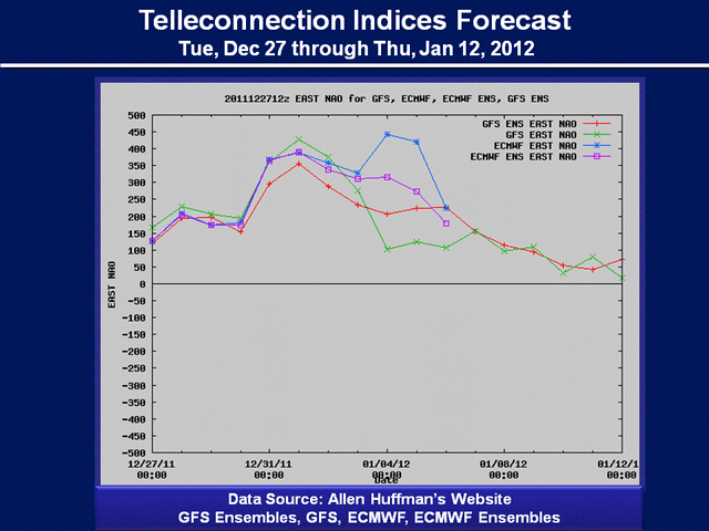
Telleconnection Indice Forecasts
– Tuesday, December 27 through Thursday, January 12


")
")
What you see with the NAO, NAO West and the AO will be trending toward the negative side. This favors the potential for a pattern over the Eastern US to a more colder period and perhaps an active period for wintry weather.
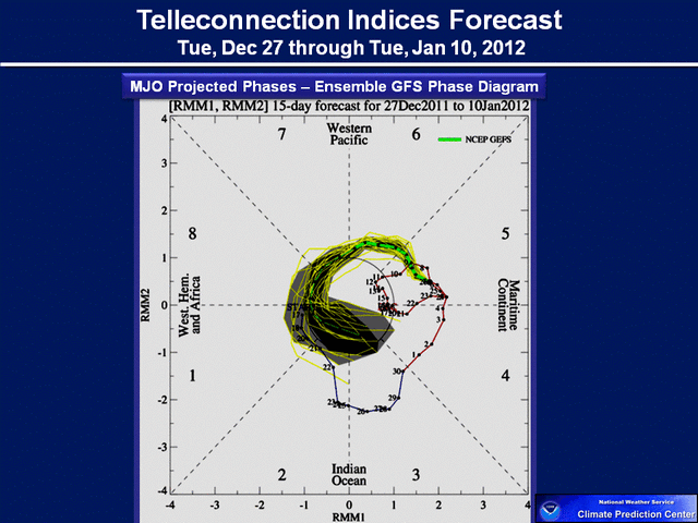

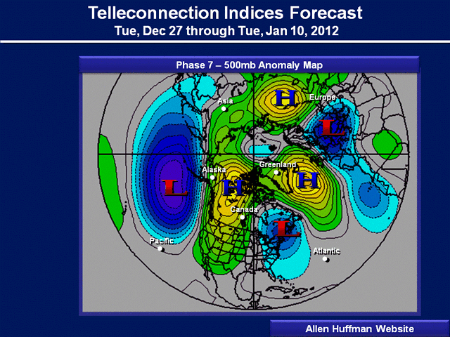
The final analyses is the MJO. I think based on what the GFS and Euro shows here is that Phase 7 could be possible. Check out the 500mb anomaly plot. This analyses was provided by Allan Huffman. Check out this link to see all these correlations. Just great stuff he developed. But this Phase 7 chart for January favors that trough over the Eastern US and that threat for wintry weather.
https://raleighwx.americanwx.com/MJO.html
*******************************************************************************
US HAZARDS OUTLOOK
NWS CLIMATE PREDICTION CENTER CAMP SPRINGS MD
300 PM EST DECEMBER 27 2011
SYNOPSIS: A STRONG LOW PRESSURE SYSTEM IS FORECAST TO MOVE ONSHORE ALONG THE PACIFIC NORTHWEST AND MOVE EASTWARD JUST NORTH OF THE CANADIAN BORDER. AN ASSOCIATED COLD FRONT COULD BRING THE COLDEST TEMPERATURES OF THE SEASON SO FAR TO LOCATIONS IN THE SOUTH AND SOUTHEAST, INCLUDING FLORIDA. DURING THE SECOND HALF OF THIS ASSESSMENT PERIOD, THERE IS A CHANCE FOR AN EXPANSION OF BELOW
NORMAL TEMPERATURES TO PARTS OF THE EASTERN STATES, WHILE THE PACIFIC NORTHWEST REMAINS WETTER THAN NORMAL.
HAZARDS
- HEAVY RAIN FOR THE PACIFIC NORTHWEST DEC 30 – DEC 31.
- MUCH BELOW NORMAL TEMPERATURES FOR ALASKA DEC. 30 – JAN 3.
- HEAVY SNOW FOR THE MOUNTAINS IN IDAHO AND EXTREME NORTHWESTERN WYOMING DEC
30 – DEC 31. - SEVERE DROUGHT FOR PARTS OF THE CENTRAL AND SOUTHERN GREAT PLAINS, DESERT
- SOUTHWEST, SOUTHEAST, WESTERN CORN BELT, UPPER GREAT LAKES, AND HAWAII.
Click on US Hazards Asssessment for the full discussion.