
(Blog Written by Donald Sutherland)
August 8-15, 2012 Thoughts:
The story of this period yet again will likely continue to be a persistence of high heat and lack of rainfall in the drought-stricken Central Plains. The potential will exist for heat to surge into the Middle Atlantic region and possibly New England later in the period.
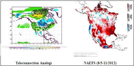
The charts shown below are as follows:
Left: Composite temperature anomalies for ENSO Region 3.4 anomalies of +0.30°C to +1.00°C, a PNA of -0.50 to +0.50, and an AO of -0.25 to +0.50 for North America.
Top Right: NAEFS forecast for the August 5-11, 2012 timeframe
In terms of rainfall prospects, the East Coast (particularly the Southeast) and the Northern Plains have prospects for above normal rainfall. The Central Plains and possibly Gulf States could be drier than normal.
Taking into consideration all of the date, my thoughts are as follows:
– Near normal in an area running from central Canada into the Northern Plains
– Near normal in California.
– Much warmer than normal in the Central Plains
– Warmer than normal across the rest of the U.S. and Canada
Finally, in terms of the analogs appearing, 70% saw less blocking than normal during the winter, while 30% saw more blocking than normal. The greatest tendency for blocking among those with less than normal blocking occurred in February. For now, much can change and nothing is cast in stone, but the state of blocking will likely be key as to whether Winter 2012-13 delivers in terms of cold and snow to portions of North America. A blocky winter (but not extreme blocky outcome like 2009-10) could see the eastern quarter to third of North America wind up colder and possibly snowier than normal, but the evolution of the drought could have an impact on snowfall possibilities. An absence of blocking could lead to widespread warm anomalies, especially if a basin-wide El Niño unfolds.
Although it is too soon for me to be sure how Winter 2012-13 will turn out, what does appear unlikely is a coast-to-coast cold outcome ala Winter 1978-79. During Summer 1978, much of the Northern Hemisphere’s land areas saw colder than normal readings (anomaly on the NCDC dataset was -0.320°C). During Fall 1978, the Arctic was covered by anomalously cold readings while the Northern Hemisphere’s land areas were somewhat warmer than normal (+0.107°C anomaly) courtesy of a very warm November. During that month, the AO averaged +2.470 as the Arctic grew especially cold. Once strong blocking developed in late December and predominated into mid-February, the bitter cold that had accumulated in the Arctic flooded into North America and Eurasia.
The opposite has been the case this summer. Much of the Northern Hemisphere has been very warm, with the Northern Hemisphere land areas seeing their warmest June on record. It remains to be seen how things will unfold during the fall.