
(Blog written by Donald Sutherland)
June 8-15, 2012 Thoughts:
The second week of June could be shaping up as the coolest week relative to normal across parts of North America. Both the forecast MJO and the teleconnection analogs suggest that an area running from the Great Lakes region into central Canada could witness cool anomalies. Most of the warmth would be confined to the western half of the U.S.
However, if one takes a look at some of the analogs coming up, one could be seeing a signal for the month to end on a hot note. Among the analogs showing up for the second week of June are 1953, 1966, 1969, and 1977. All four of those years witnessed excessive heat in the closing 7-10 days of June. Moreover, 1969 was the leading June analog.
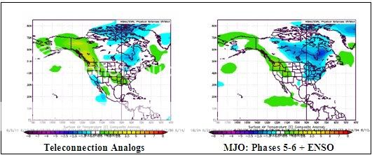
The charts below are as follows:
Left: The composite temperature anomalies for ENSO Region 3.4 anomalies of -0.2°C to +0.5°C, a PNA of 0.00 to +1.00, and an AO of -0.50 to +0.50 for North America.
Right: MJO of Phases 5-6 (Amplitude 0.5 to 2.0) during Neutral ENSO conditions in June
All said, my thoughts are as follows:
– Great Lakes region to the James Bay area of Canada: Generally cooler than normal readings.
– Eastern third of the U.S. and Quebec eastward in Canada: Near normal to somewhat above normal readings
– Western half of the U.S., except for the Great Lakes region/western third of Canada/Alaska: Generally warmer than normal