
Good Evening Everyone,
I’m a bit short on time, so my written discussions will be brief. Right now, Monday is looking to be the the most active. Excessive rainfall and a round of severe weather possible on Monday. Heavy rainfall likely late tonight into the first half of Monday, followed by the threat of severe weather Monday evening. Currently, the Storm Prediction Center has placed the entire region in slight risk category. Beyond Monday, we turn chilly temperature wise and less stormy. The one item to keep a close eye on and that is if you have any plants and vegetation as temperatures could drop to near freezing levels later in the week and into the following week. So, keep an eye on the forecast.
For official outlooks, please check out the following links
– NWS Daily Weather Briefing
– NWS Mount Holly NJ Facebook
– NWS Mount Holly, NJ Twitter
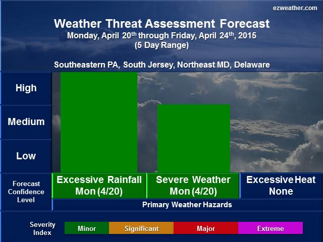
Weather Threat Assessment Forecast
Monday, April 20th through Monday, May 4th
Issued: Sunday Evening, April 19th
5 Day Period (Monday, April 20th through Friday, April 24th)
Note: Click on thumbnail image above to view in full. Also, for further details on table legends and forecast geographic location references, scroll down to the bottom of this blog entry under “Background Information”.
Weather Discussion
- Opening Remarks
- The most active day will be the first day of this period. A round of heavy rainfall and perhaps some severe weather on Monday. Beyond this day, cooler than average temperatures likely rest of period.
- Sensible Weather
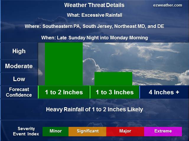
- New trough will be begin to overtake the Eastern US. A warm front will bring in the heavy rain late tonight into the first half of Monday. Rainfall amounts about 2 inches for the entire area. Then a break in the action. A cold front will move the region early Tuesday morning. Then cooler than average temperatures likely for the rest of this period.
- Weather Threats
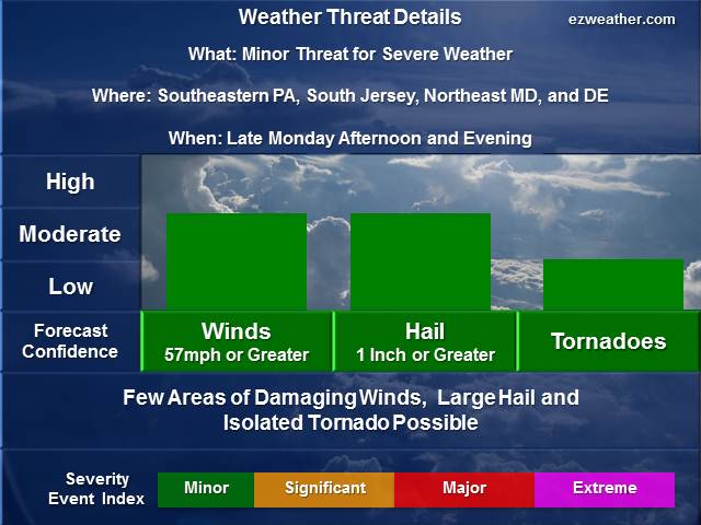
- Two threats right now is the excessive rainfall and severe weather. Right now, the region will experience some heavy rainfall late Sunday night into mid morning Monday. Most of the model guidance indicates about 1.50 inches. I’m thinking this will be a minor excessive rainfall event. Some minor flooding expected, but nothing major. But the heavy rain will impact the morning commute and air travel. So, thats the biggest impact. Then the severe weather threat possible late Monday afternoon/evening. A cold front will approach from the west and move through the region early Tuesday morning. Right now, I don’t expect this to be significant at this time, but a minor event. I don’t think there will be a lot of locations will get hit with damaging winds and large hail. Now, the Storm Prediction Center has the region under slight risk. Basically, this threat category states “means short-lived and or/ not widespread, isolated intense storms possible. Winds 40 to 60 mph, Hail up to 1” and low tornado risk. I think the majority of the threat will likely be some gusty winds to 50 mph, pea size hail and some very heavy rainfall.
6 to 10 Day Period (Saturday, April 25th through Wednesday, April 29th)
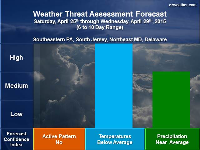
Note: Click on thumbnail image above to view in full. Also, for further details on table legends and forecast geographic location references, scroll down to the bottom of this blog entry under “Background Information”.
Weather Discussion
- Opening Remarks
- This period will be a chilly one, but no major storms in this period.
- Sensible Weather
- The upper air pattern will feature a trough over the Eastern US. This basically means colder than average temperatures likely. Precipitation should be near average.
- Weather Threats
- For this period, I’m not forecasting any weather threats. The one item I to be concern with is potential for frost/freeze conditions. Temperatures may get down to freezing, so this could impact plants and vegetation.
8 to 14 Day Period (Thursday, April 30th through Monday, May 4th)
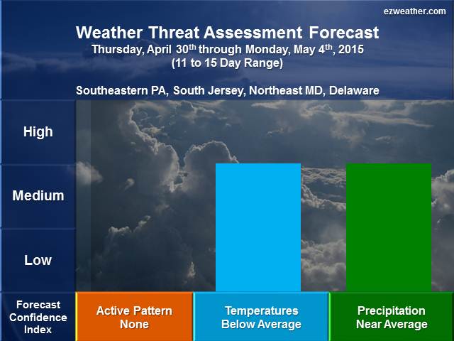
Note: Click on thumbnail image above to view in full. Also, for further details on table legends and forecast geographic location references, scroll down to the bottom of this blog entry under “Background Information”.
Weather Discussion
-
- Opening Remarks
- This period will be similar, but moderation likely, meaning warmer temperatures in this period. The pattern should be quiet.
- Sensible Weather
- The upper air pattern will feature a trough exiting the Eastern US and being replaced with some ridging aloft toward the end of this period. Basically, we should see temperatures to slowly moderate at the end. I’m still going with below average temperatures, but should be the first half of the period, followed by near average temperatures. Precipitation should be near average.
- Weather Threats
- Right now, no weather threats are being forecasted. There may be a period where overnight temperatures could drop to freezing, which means some frost and freeze conditions could be possible. So, this could impact plants and vegetation.
- Right now, no weather threats are being forecasted. There may be a period where overnight temperatures could drop to freezing, which means some frost and freeze conditions could be possible. So, this could impact plants and vegetation.
- Opening Remarks
X
************************************************************************************************************************************************
Background Information
- I am very excited to provide a new forecast product for the Philadelphia Area, which includes Southeastern Pennsylvania, South Jersey, northeastern Maryland, and Delaware. In here will be a new experimental product that I’ve produced for the Philadelphia Area.
- Right now, I like to issue this product once a week, especially on Sundays. If time permits, I’ll issue a new forecast during the week.
- This forecast will aide pretty much everyone from Public, Emergency Management, SKYWARN, and RACES. The idea is to provide everyone with a forecast that gives them the needed lead time to prepare for significant hazardous.
- Finally, below is further background on my forecast tables and geographic locations
- Table Legend
- Forecaster Confidence
- Severity Event Index: Minor, Significant, Major, Extreme
- Forecast Geographic Locations
- Southeast Pennsylvania: Chester, Montgomery, Bucks, Delaware, and Philadelphia
- South Jersey: Burlington, Ocean, Camden, Gloucester, Salem, Cumberland, Atlantic, Cape May
- Northeastern Maryland: Cecil, Kent, Queen Anne’s, Caroline, and Talbot
- Delaware: New Castle, Kent, and Sussex
- Table Legend